Supporting Sponsors
Contributing Sponsors
Other Contributors
Want to be a Sponsor?
Please email info@cambatrails.org
Post Race Report
A huge THANK YOU to the racers, sponsors, volunteers, and spectators for making the 2024 race a massive success! A good time was had! The proceeds from the race will support the CAMBA Trails budget!
Race Distances
Participants can choose one of 4 distance options to match their personal endurance goals; approximately one hundred, sixty-five, thirty or fifteen miles of sweet northern Wisconsin dirt, with the great majority of each distance being on singletrack. NEW to 2024…the 100 mile now has a team event! Bring along friends and make a day of it.
Course
All races start and end behind the SC Johnson Outdoor Center at the OO Trailhead.
The race distances head north along the same route toward Cable with the 15 mile turning back first to finish at OO. The 30 mile turning back after hitting Evenflow and Once and finishing at OO. The 65 mile and 100 mile also head out to the Namakagon Cluster trails and then return to OO. The 65 finishes when it gets back to OO. Only the 100 mile race heads south of OO and makes its way down to the Hatchery Trails before returning to OO.
The course is run on and permitted through the Chequamegon-Nicolet National Forest, Sawyer County Forest, and Bayfield County Forest.
Course Ride with GPS files for the race have been updated.
100 mile course: https://ridewithgps.com/routes/46585262
65 mile course: https://ridewithgps.com/routes/46594991
30 mile course: https://ridewithgps.com/routes/46594077
15 mile course: https://ridewithgps.com/routes/47764861
For relay participants:
Leg 1: https://ridewithgps.com/routes/46595044
Leg 2: https://ridewithgps.com/routes/46595055
Leg 3: https://ridewithgps.com/routes/46595017
Leg 4: https://ridewithgps.com/routes/46594911
We strongly encourage participants to download the Ride With GPS file to their computer or phone for several reasons:
— the files include cues to warn of upcoming turns, roads and trail crossings;
— the files include elevation profiles to allow riders to see what is coming up.
This is a self supported race in the wilderness. Riders should be self contained, with both paper and electronic maps.
Water on the 100 and 65 courses is available at these locations and approximate mileage:
- 8.5 miles – High Point Birkie warming hut (the Birkie skate trail crosses the road and the hut is approximately 100 yards off to the rider’s left. This may require you to push a button to get water pressure. Water is not guaranteed but usually available)
- 40.5 miles – Namakagon Town Hall – water is available. This will also be the drop bag destination where you could put drinks in your drop bag.
- 59.5 miles – Boedecker Birkie warming hut (the Birkie skate trail crosses the road and the hut is approximately 25yards off to the rider’s right. This may require you to push a button to get water pressure. Water is not guaranteed, but usually available)
- 62.5 miles – OO Trail head. This is where you started and the 65 milers will finish. Feel free to stop at your car or use the amenities in the SC Johnson Family Outdoor Center (water, bathrooms, vending machine).
- 79 miles – Hatchery Creek – water is available at the building
- There is also water available at the Gravel Pit Birkie warming hut similar to High Point and Boedecker, however, this would require navigating off the course and back onto the course approximately 0.3 miles.
Water on the 30 mile course is available at these locations and approximate mileage:
- 8.5 miles – High Point Birkie warming hut (the Birkie skate trail crosses the road and the hut is approximately 100 yards off to the rider’s left. This may require you to push a button to get water pressure. Water is not guaranteed but usually available)
- 26.5 miles – Boedecker Birkie warming hut (the Birkie skate trail crosses the road and the hut is approximately 25yards off to the rider’s right. This may require you to push a button to get water pressure. Water is not guaranteed, but usually available)
Course marking info
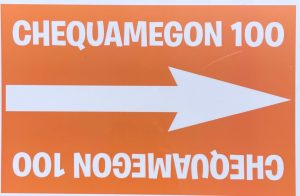
The course will be marked with bright orange signs like the one below. Your chief of course will have 600 of these up throughout the 100 miles. The course will be “Open” to other traffic so you will need to be cautious of cars, ATVs, hikers, bikers, bears, etc. Use caution crossing roads and other intersections.
Bag Drops
A 1 gallon ziploc bag will be given to 65 and 100 mile participants when you collect your number plate. Fill them with your fuel of choice, give them to a volunteer in the parking lot collecting them in a vehicle and once you hit the Namakagon Town Hall point at ~40 miles, you will be reunited with this bag of goodness.
Cutoff Times
We plan to have several independent course sweeps. These sweeps will be heading out at specific times from the following points on the course. If you do not make it to that point by that time, it’s up to you to decide to continue or find a short cut back to the finish.
- 12PM – C8 @ ~21.6 miles for the 65 and 100 mile races (Esker parking lot where Dirt Candy ends and Esker begins where the route crosses Spider Lake Fire Lane)
- 3PM – 41 miles for the 65 and 100 mile races (Namekagon Town Hall bag drop stop)
- 4PM – 65 miles for the 100 mile race (This is the OO start/finish)
- 6PM – 78 miles for the 100 mile race (Hatchery Creek)
Other Reminders
- Bug spray – If you plan to stop anywhere on the course, it’s highly recommended that you have applied some bug protection. The mosquitoes this year are aggressive and plentiful!
- Food/cash – There will be food again this year at OO as well as beverages!
- Raffle/cash – Bring some cash for the raffle! It will have a ton of stuff from our sponsors!
- Returning your drop bag – we will bring back the drop bags to the start finish. The precise time of this is not known, but most likely ~4PM. Anything left at OO after 7PM will be donated or thrown away.
- If you DNF, please check in at the timing tent to tell the timers
- If you’re riding the 100 mile event, please check in at the timing tent as you pass through on your way south from OO to Hatchery.
- If you’re riding the 100 mile event and decide (while already started) to switch to the 65 mile event, THAT’s OK, just tell the folks at the timing tent and we’ll switch your category. (This will make you ineligible for a 65mile top 3 award though).
- Awards will be ~ 30 min after the 3rd place finisher of each race.
What if it rains?
We’ll be updating this page with contingencies as well as the time we’ll make “the call”. The CAMBA trails hold up extremely well to rain so a significant amount would be required for us to cancel or postpone the event.
After party?
Of course! We plan to have food and beverages after you cross the line!
Volunteer at the Cheq100
Take a look HERE at how you can get involved and make this race a success.
Questions or feedback about the race…
Please email us at info@cambatrails.org
